
About the Driftless Area
What is the Driftless, and why is southeastern Minnesota not considered part of it?
While no formal boundaries define the Driftless, scientists generally agree that it encompasses much of western Wisconsin and extreme northwestern Illinois. Southeastern Minnesota and northeastern Iowa are often included in descriptions and maps detailing the boundary of the Driftless, but closer examination reveals that these areas do not contain some of the key characteristics that geologically define the Driftless.
There have been many periods of glaciation over the last 2.58 million years. Although the most recent glaciers did not reach this area, glaciers did reach southeastern Minnesota during earlier glaciations. The absence of glacial “drift”—glacial deposits of stone and debris—during the most recent glacial period is what led parts of Wisconsin and Illinois to be described as driftless. Geoscientists today typically avoid the antiquated term “drift” because it originated from the mistaken belief that stones and debris floated around the globe on icebergs.

In the true “Driftless Area,” the failure of the most recent glaciers to penetrate the region contributed to its defining geologic characteristics: steep hillsides, narrow valleys, and dramatically uneven terrain. Glaciers were unable to blanket this landscape because they were blocked by the highlands of northwestern Wisconsin while simultaneously being diverted through troughs created by Lake Superior and Lake Michigan.
Ice, Water, and Wind
As glaciers melted for the final time along the edges of the Mississippi approximately 13,000 years ago, massive quantities of water released by melting ice sheets (“meltwater”) eroded the sedimentary rocks below. meltwater helped shape the surrounding landscape. This process, known as “inverse topography”, resulted in a region characterized by flat plateaus above bluff tops, dissected by numerous streams and rivers flowing toward the Mississippi.
The region’s loess—wind-blown silt—becomes thicker toward the Mississippi for a fascinating reason. Sand moving along the ground helped keep finer dust suspended in the air. As the sand settled into deep tributary valleys, the remaining dust traveled farther before settling downwind.
Researcher Bill Zanner studied the periglacial area at the edge of the ice and mapped unusual linear dunes that demonstrate how sand moved through the region in strong glacial winds. He also uncovered permafrost features such as frost polygons. Zanner’s research contributed to a broader regional study of wind features in southeastern Minnesota and surrounding areas.
Rivers and Caves
The proximity of the glaciers also created a tundra-like environment, freezing the ground and temporarily preventing groundwater from entering the region’s caves. These caves, which formed as rivers carved through the landscape, offer a remarkable window into the region’s past. Speleothems—mineral formations within caves—preserve records of changing climate conditions, revealing clues about past vegetation, average temperatures, major floods, and periods of permafrost. The caves also sheltered fascinating Ice Age animals, including saber-toothed cats. Dr. Greg Brick has written extensively about the caves and geology of our region.
The region’s rivers provide another important piece of this geologic story. The Mississippi River and its tributaries vary in age, but they are ancient. Glaciers sent meltwater down some rivers and even into caves, but that water filled existing valleys rather than creating them. Because glacial meltwater carries large amounts of sediment, it does not necessarily deepen stream valleys. However, changes in sea level and local base levels can lead to rivers incising—a process that causes them to cut more deeply into the landscape.
The Mississippi responded to lower sea levels during periods of glaciation by deepening its channel. As it did, its tributaries were also forced to deepen. Local base levels changed as large glacial lakes drained, a glacial forebulge shifted, and other river dynamics reshaped the landscape. Research by Eric Carson on the capture and reversal of river flow in western Wisconsin illustrates one of the more dramatic reorganizations of the region’s drainage network.
Something Underfoot
An Ancient Sea
The geology of this area is also revealed through fascinating features beneath the Earth’s surface. The rock beneath our soils is mostly sandstone and limestone, formed from approximately 500 to 375 million years ago, when southern Minnesota and surrounding areas were covered by a shallow tropical sea. Many of the sea creatures living at the time had shells made of calcium (like our teeth and bones). As these organisms died over millions of years, their remains contributed to the formation of limestone rich in calcite, while sandy shorelines contributed to layers of sandstone. Today, fossils from this ancient sea can still be found along roadsides, in stream beds, and on rock faces.
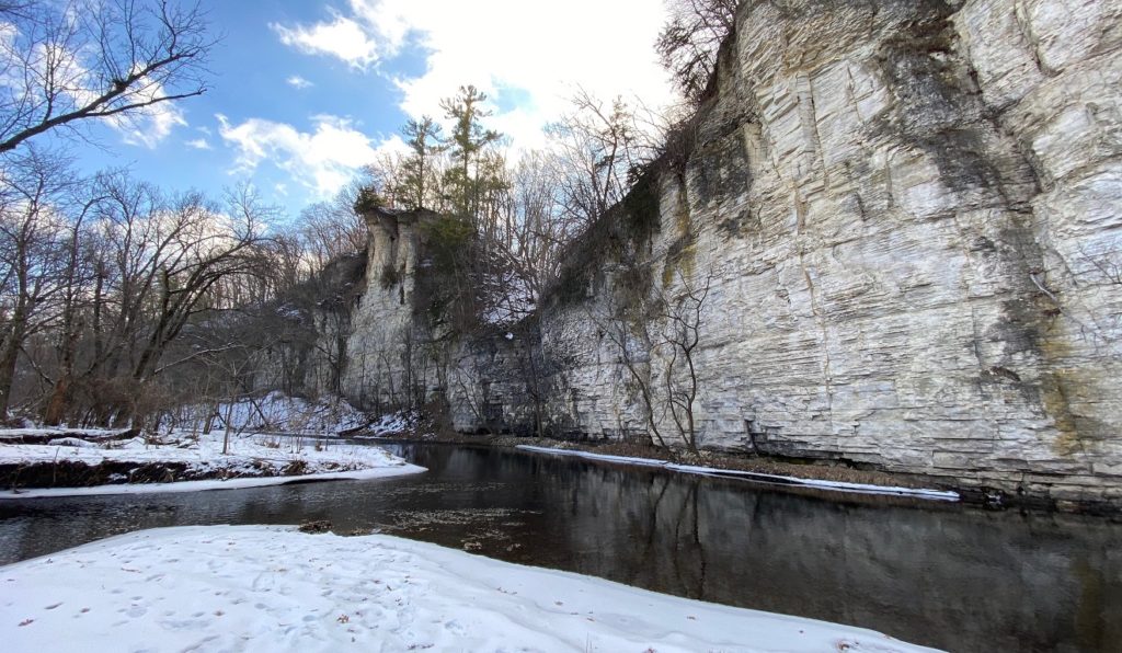
Just as our teeth can develop cavities when exposed to acidic substances like soda pop, limestone can develop cavities from rainwater, which becomes slightly acidic when it falls to the Earth’s surface. Over time, this process has created remarkable geologic formations throughout the driftless region, including caves, underground rivers, springs, and sinkholes.
Karst
Nearby Fountain, Minnesota, is known as the “Sinkhole Capital of the United States,” and Eagle Bluff is close to both Niagara Cave and Mystery Cave, which are open to the public. This type of landscape, characterized by soluble limestone and features such as sinkholes and caves, is called karst. Outdoor School groups can explore this fascinating geology firsthand in Eagle Bluff’s Karst Geology class. While karst occurs around the world, it is especially notable in this part of the Upper Midwest and is rarely found outside of the Driftless Area.
People and Place
Prairies, Forests, and Bluffs

The diversity of landscapes found throughout this region supports an equally diverse range of ecosystems. On wide, open blufftops, fires sparked by lightning and intentionally set by Indigenous peoples helped create and maintain prairie and oak savanna landscapes.
On south-facing bluff slopes, thin soils and unusually warm temperatures create an almost desert-like habitat populated by unique plants and animals, including prickly pear cactus and timber rattlesnakes. North- and east-facing slopes, shaded from intense sunlight and protected from frequent fire, support moist, mature hardwood forests filled with species such as maple, basswood, and white oak. River bottoms, which flood frequently, support their own distinctive plant and animal communities.
This wide array of plant and animal communities has long attracted people to our region. As the glaciers retreated and humans were able to expand southward, they hunted now-extinct megafauna like mammoths and mastodons that roamed the area. As settlements expanded and communities developed, people used caves and sheltered valleys for protection through harsh winters, in some cases leaving still-remaining art etched on the rock walls.
Agriculture developed in fertile river valleys, contributing to more established and permanent settlements. Around 1,000 years ago, growing societies began expressing their spirituality through the landscape itself, creating tens of thousands of earthen mounds in forms ranging from lines and circles to complex shapes such as bears and thunderbirds. Some of these can be viewed at Effigy Mounds National Monument along the Mississippi River in northeastern Iowa.
Genocide and Dispossession of Native Peoples
This area was not immune to the genocide and dispossession of Native peoples following European settlement. The Dakota (Sioux), Ioway, Ho-Chunk, Sauk, and other Indigenous peoples were removed or killed during the 18th and 19th centuries.
Settlement and Agriculture
European settlers, many from northern and central Europe, subsequently took advantage of the region’s rich soils and abundant forests to establish farming communities across what became Wisconsin, Minnesota, Iowa, and Illinois. Early farmers grew crops such as wheat, oats, barley, and corn while raising livestock, particularly dairy cattle, for food and income.
Unlike the flatter terrain surrounding the region, however, these steep hillsides were poorly suited to conventional agriculture. Farmers, and the landscape itself, suffered from severe topsoil erosion and runoff caused by plowing and overgrazing.

In the 1930s, beginning in Wisconsin’s Coon Valley and later spreading throughout the region, conservation practices were introduced to address the effects of industrial agriculture. Steep upper slopes were fenced off from grazing dairy cattle and, in some places, restored to native oak savanna or mixed woodland. Contour strip cropping—planting crops in strips that follow the natural contours of the land—became increasingly common. As erosion declined, water quality improved.
Conservation Takes Root
Today, the region remains a leader in sustainable agriculture. Many beef producers use managed grazing systems in which cattle are moved frequently to mimic the movement of bison herds across the prairie, while organic and heirloom agriculture thrive around communities such as Decorah, Iowa, and Viroqua, Wisconsin.
Now and Forever
Today, our region is widely recognized as a destination for biking, birding, local food, art, and outdoor recreation.
Over the past several decades, many former railroad corridors have been converted into bike trails, creating some of the most scenic cycling routes in the Upper Midwest. Thousands of people flock to the Mississippi Flyway each spring and fall to witness migrating birds traveling along the river valley, which serves as a natural highway for transient birds.
The region’s rivers and streams draw visitors from across the country to fish for trout in cold, clear, spring-fed streams or paddle the waterways that eventually drain into the Mississippi River.
Eagle Bluff sits just outside Lanesboro, Minnesota, a community known for its bed-and-breakfasts, outdoor recreation, and vibrant arts scene.
Learning from the Land
We are fortunate to be taking our turn living within this remarkable landscape. Because of the unique geographic challenges to our region, generations of people who live here have fostered a closer relationship to the land. As an organization which strives to connect people to the earth and each other, we take care to use the natural features of our landscape to teach and inspire everyone who comes here to learn: Fourth graders crouch low in our tall grass prairie, mimicking predator-prey relationships in a game of camouflage. Sixth graders identify and make observations about 15 different trees in our mixed forests. Biology students from Lanesboro High School conduct annual water quality tests on the Root River. Young professionals from across the country walk these bluffs as they learn to become environmental educators.
In whatever way you choose to get to know this region, we hope to see you here soon!